
Best Cycling Navigation for City Riders: 2026 Guide
Table of Contents
- Quick Comparison: Top Cycling Navigation Options for City Riders
- How We Tested: Our City Navigation Methodology
- Beeline Velo 2: Simple, Affordable City Navigation
- What Is the Best Cycling GPS for Navigation?
- How to Find Bike-Friendly Routes in Your City
- Cycling Computer vs Phone Navigation: Which Works Better in the City?
- Strava vs Komoot for Cycling: Route Discovery Compared
- Privacy, Costs, and Limitations: What to Know Before You Buy
- Frequently Asked Questions
Last Updated: October 5, 2026
Quick Comparison: Top Cycling Navigation Options for City Riders
Finding the best cycling navigation for city streets comes down to one question: does the tool route you onto bike-friendly roads, or just any available street?
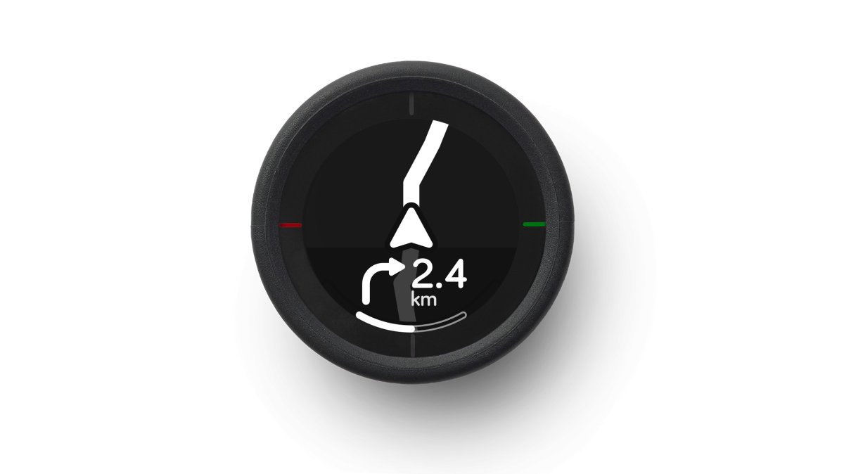
The short answer: a dedicated device like the Beeline Velo 2 wins for most urban riders because it shows one clear arrow instead of a distracting map. Phone apps still work and cost nothing up front.

| Option | Upfront Cost | Best For | Main Trade-Off |
|---|---|---|---|
| Beeline Velo 2 | $99.00 | Daily commuters who want a clutter-free screen | Navigation and tracking only, not a full training computer |
| Phone with a free app | $0 plus data | Riders testing the waters | Battery drain and glare on bright days |
| Premium GPS computer | Several hundred dollars | Racers tracking power and heart rate | Cost and a steep learning curve |
| Paper cue sheet | Under $5 | Riders who want zero tech | No rerouting when you miss a turn |
How We Tested: Our City Navigation Methodology
We judge every option on five criteria, scoring each from 1 to 5, whether it is a device or an app.
- Route quality: Does it favor bike lanes and quiet streets over arterials?
- Clarity at a glance: Can you read the next turn in under two seconds?
- Rerouting speed: How fast does it recover when you miss a turn?
A common mistake is testing navigation on a weekend leisure route. City conditions differ: intersections come every few hundred metres, and a wrong turn costs you a light cycle. That is why we weigh rerouting and glanceability heaviest.
Beeline Velo 2: Simple, Affordable City Navigation
The Beeline Velo 2 is our top pick for city riding, and the reason is restraint. It shows a single arrow pointing toward your next turn, so you never take your eyes off traffic to interpret a map.
What's in the Box and How It Works
The package includes the Velo 2 Navigation device, a USB-C charge cable, a universal handlebar mount, and a quick start guide. You plan the route in the Beeline app, and the device displays turn-by-turn directions through a bright, simple interface. Activity tracking runs alongside navigation, so your commute doubles as ride data.
Mounting Options for Any Handlebar
The Beeline Velo 2 Universal Mount ($19.99) uses strong elastic bands and a silicone protective rubber base to grip handlebars securely. It is already included with the Velo 2, so most riders need nothing else. If you prefer a cleaner cockpit, the Beeline Velo 2 Stem Cap Mount ($19.99) replaces your standard 1 or 1 1/8 inch headset top cap and holds the device in view with no bar clutter.

What Is the Best Cycling GPS for Navigation?
The best cycling GPS for navigation is the one that gets you to your destination without demanding attention. The Beeline Velo 2 fits: it handles turn-by-turn guidance and activity tracking, leaving heavy data analysis to tools built for it.

If you already own a feature-rich GPS computer, the honest question is whether you use half of what it does. For a broader look at how these devices compare on the road, see REI's guide to bike computers and GPS units.
How to Find Bike-Friendly Routes in Your City
Finding bike-friendly routes starts with a tool that scores streets by comfort, not just distance. The shortest route is often the worst: a direct line down a busy arterial beats a longer path through side streets on paper and loses badly in practice. The harder question is whether a tool actually knows your city's infrastructure, and that varies more than most roundups admit.
Why City-by-City Accuracy Matters More Than Feature Lists
Every major route planner claims to prioritize bike lanes. What separates them is how current and complete their infrastructure data is in the city you actually ride.
A practical pattern: tools leaning on crowdsourced edits tend to be strong in dense, bike-heavy neighborhoods and thin in suburbs or new areas. Tools pulling from municipal GIS feeds can be accurate on paper but lag when a protected lane is under construction or a new one opens.
A Repeatable Test You Can Run on Your Own Commute
Rather than trust a feature description, test any planner against the same route three ways:
- Plan your normal commute and inspect the preview. Count how many blocks use a protected lane versus a shared lane versus a plain arterial. Note any long stretch on a road with no bike infrastructure.
- Ride it at rush hour. Watch for where the tool routes you onto a street that looks calm on a map but carries fast turning traffic. Note every point where you would not let a less-confident rider follow you.
- Ride it again on a quiet Sunday and force a wrong turn. Time how long it takes to reroute and whether the new route keeps you on comfortable streets or dumps you onto the nearest arterial.
The gap between the rush-hour and Sunday rides tells you more than any spec sheet. A tool that reroutes you onto a protected lane beats one that reroutes you onto the fastest available road.
Signals to Check in Any Route Preview
When you plan a commute, check these signals before trusting the line on the map:
- Whether the path uses protected bike lanes or shares the road with traffic
- Whether it crosses major intersections at signals or mid-block
- Whether elevation gain is spread out or concentrated in one climb
- Whether the app offers a "quiet" or "comfort" routing preference you can set as default
For official guidance on street design and where cycling infrastructure is documented, the Federal Highway Administration's bicycle and pedestrian program is a useful reference. It explains the standards cities follow, which helps you judge whether a route actually uses safe infrastructure.
Cycling Computer vs Phone Navigation: Which Works Better in the City?
A cycling computer wins for city navigation because it survives a full commute on one charge and stays readable in direct sun.
Phones drain fast when the screen stays on for navigation, and mounted phones take a beating from vibration and rain.
| Factor | Cycling Computer | Phone Navigation |
|---|---|---|
| Battery life | Lasts a full commute and more | Drains quickly with screen on |
| Sunlight readability | Built for direct sun | Often washes out |
| Weather resistance | Designed for rain | Needs a case |
| Cost | One-time purchase | Free app, data costs apply |
| Distraction risk | Minimal, single-purpose | Notifications interrupt |
If you want to keep your phone stowed and your handlebars clean, the Beeline Velo 2 is the simplest way to do it.
Strava vs Komoot for Cycling: Route Discovery Compared
Strava and Komoot both help you discover cycling routes, but they aim at different riders. Strava leans on its community: segments, leaderboards, and routes other riders have logged.
For city commuting, the distinction matters less than you might expect, both can plan a route from A to B. The bigger question is how each handles urban reality, like construction closures and one-way streets.
Where Each One Actually Helps in the City
Strava's strength for urban riders is heatmaps and popular segments. If a street shows heavy rider traffic at commute hours, that is real-world evidence it is rideable, not just a map's guess.
Komoot's strength is surface and waypoint detail: you can see whether a segment is paved, gravel, or unpaved, and set waypoints for a destination like a coffee stop or train station.
E-Bikes and Multimodal Trips: The Angle Most Roundups Skip
If you ride an e-bike, route choice changes. A long, steep climb that is fine on a road bike can drain a battery faster than expected, and a planner that ignores elevation can leave you pedaling a heavy bike home on low charge.
For multimodal trips, plan the cycling legs separately from the transit leg. Neither app reliably combines a bike route with a train schedule, so use the app for the bike portion and a transit app for the rest.
A Simple Way to Decide
If you want to find new routes and see where other riders actually go, Strava's community data is hard to beat. If you want to plan a specific trip with surface detail and waypoints, Komoot's builder is stronger. The League of American Bicyclists' resources on safe cycling offers practical guidance on riding confidently in traffic, which no app can replace.
Privacy, Costs, and Limitations: What to Know Before You Buy
Two things deserve scrutiny before you buy any navigation tool: what it does with your location data, and what it costs over time. Free apps are rarely free, many fund themselves by collecting ride data, and some share location with advertisers.
Costs add up in ways the sticker price hides. A free app plus a phone mount plus a battery pack can approach the price of a dedicated device, premium GPS computers run into the hundreds before sensors, and advanced route planning often sits behind a monthly fee.
Frequently Asked Questions
Is a cycling computer or phone better for city navigation?
It depends on your priorities. A phone running a free app works fine if you have a secure mount and a battery pack, but phone batteries drain quickly with GPS active. A dedicated cycling navigation device like the Beeline Velo 2 keeps your phone stowed and safe while still delivering turn-by-turn directions. For daily commutes where reliability matters, a standalone device reduces distraction and preserves phone battery for emergencies.
How do I find bike-friendly routes in a city?
Start with apps that let you set route preferences for bike lanes and quiet streets. Beeline's app, for example, builds routes that favor cycling infrastructure over busy roads. Cross-check with local bike maps and rider forums, since infrastructure changes faster than map data updates. Test your commute route on a weekend before relying on it for daily riding.
What is the best cycling GPS for navigation?
The best cycling GPS for navigation depends on your budget and how much data you want while riding. The Beeline Velo 2 at $99 offers simple turn-by-turn directions through a bright, compact screen, making it a strong option for commuters who want navigation without complexity. Riders who need detailed performance metrics may prefer a full-featured cycling computer, but for pure city navigation, simplicity often wins.
Do I need a GPS device for bike navigation?
Not strictly, but a dedicated device solves several phone-related problems: battery drain, screen glare, weather exposure, and the temptation to check notifications mid-ride. If you commute daily and want consistent, distraction-free navigation, a device like the Beeline Velo 2 keeps your phone safely in your pocket. If you ride occasionally and know your routes, a phone app may be sufficient.
Can cycling apps avoid busy roads?
Most route-planning apps let you choose preferences like avoiding highways or favoring bike lanes. Beeline's routing prioritizes bike-friendly streets, and apps like Komoot and Strava offer similar options. Accuracy varies by city, so verify your route before committing. If an app routes you onto a road that feels unsafe, flag it or switch to a parallel quiet street and save that adjustment for next time.
City navigation rewards clarity over features. The rider who glances down, sees one arrow, and looks back up is safer than the rider squinting at a map. Beeline Velo builds for exactly that rider. The Velo 2 pairs a bright, simple interface with app-based route planning and activity tracking, comes with a universal handlebar mount in the box, and costs $99.00 with no subscription. Shop Velo 2 and keep your eyes on the road.